China’s Belt and Road Initiative: Connectivity or Fragmentation?

It comes as no surprise to anyone familiar with China’s Belt and Road Initiative (BRI) that the trillion dollar project is about more that just boosting global economy. This blog provides an overview of the BRI and the potential environmental repercussions that may follow.

The Revived Silk Road

The Belt and Road Initiative (BRI) established in 2013 by China’s President Xi Jinping is a trillion dollar project to connect Asia to Africa and Europe through a series of land and maritime networks aimed at increasing trade, economic growth and regional integration (European Bank, 2019).

The project was inspired by concept of the ‘Silk Road’ established during the Han Dynasty, 2000 years ago, an ancient network of trade routes that connected China to the Mediterranean via Eurasia. Apart from the ’21st Century Silk Road’, the BRI has also been referred to as ‘One Belt One Road’.

BRI

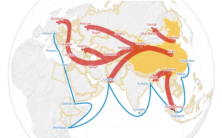
The Belt and Road Initiative spans across 71 countries, including 60% of the world’s population and over 1/3 of global trade (The World Bank, 2019). The image visualises the belt land corridors (red) and maritime pathways (blue) connecting China (yellow) to parts of Africa, Asia and Europe. Image from The Guardian (2018)

The project ultimately enables poor, underdeveloped countries to obtain hard infrastructure (through Chinese investments) that would boost local economies which otherwise would be nearly impossible to achieve. Hence, the key nations targeted in the BRI are countries like Myanmar and Pakistan that globally rank 145th and 147th respectively in the United Nations Human Development Index (HDI) (ChinaPower, 2019).

The BRI doesn’t just intend to build infrastructure to connect nations in terms of transportation. Railways and maritime routes aside, the project seeks to establish energy infrastructure and “special zones” within participating nations that would generate economic revenue for both the nation involved and China. We’re talking hydropower dams, deep sea ports, crude oil pipelines, coal-fired power plant, gas pipeline, grid connections, major bridges, highways and numerous industrial parks (these are just a select few from Southeast Asia)!

2019-02-16 (2).png

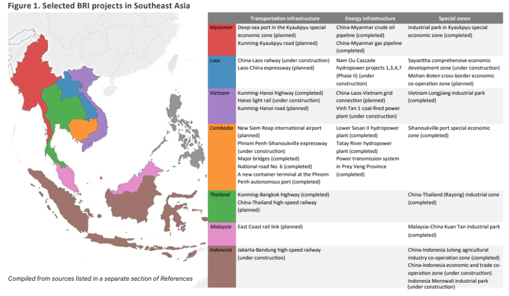
List of special zones, transportation and energy infrastructures in various stages of planning and construction within Southeast Asia as part of the BRI (Stockholm Environment Institute, 2019).

At present, the plan extends to 65 countries with a combined GDP of $23 trillion and includes about 4.4 billion people. For more overview on the BRI, watch this video!

Ecological Fallout

The six continental corridors providing key linkages in this project involve highways, rail lines and dry ports located within remote and highly biodiverse areas. Likewise deep-sea ports and cargo centers dotted along the coasts of the South China Sea and Indian Ocean are known to encroach ecologically sensitive areas (EESI, 2019). Over 1739 Important Bird Areas and Key Biodiversity Areas are at risk of disturbance, with further potential for detrimental impact to over 265 already threatened species.

Several projects have received fierce protests and condemnation for the threat it poses to native wildlife and their habitats. The building of a BRI dam in Indonesia would mean flooding and destroying a huge portion of the Batang Toru jungle, which is the only known home of the world’s rarest great ape, the Tapanuli orangutan. Although multilateral financiers have deemed this project too ecologically detrimental to fund, the state-owned Chinese company running the project may well receive funding from the state-owned Bank of China.

01581263xxx.jpg

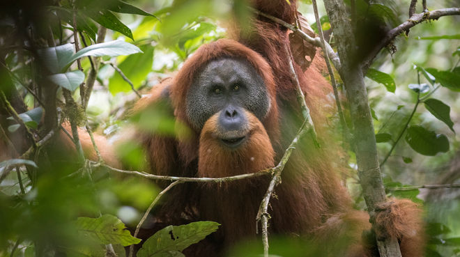
A Tapanuli orangutan — the species was only discovered in 2017 and is already facing extinction with only over 800 individuals persisting in the wild. Sign a petition to stop their habitat from being destroyed. Image from Rainforest Rescue (2019).

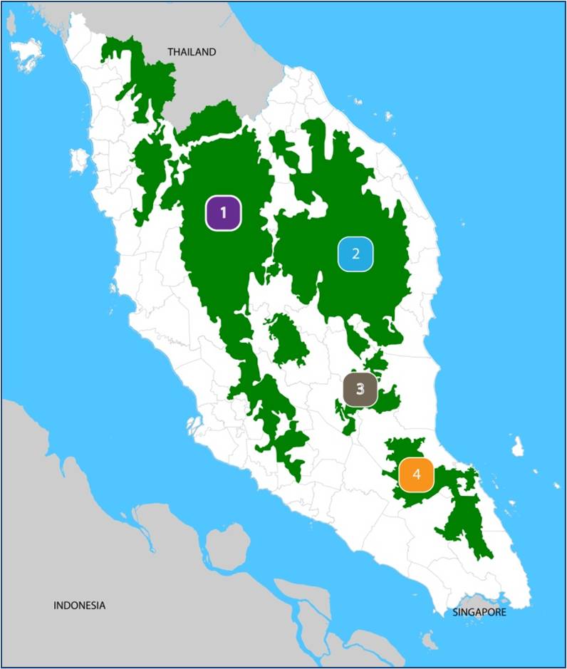
These types of project also threaten the livelihood of people who rely heavily on local environmental resources especially due to alterations to ecosystems. A proposed dam in the Mekong River, Cambodia, could severely reduce local fishery yields, affecting not just fishermen in Cambodia but downstream in Laos and Thailand too. Moreover, the increased access to undeveloped areas of forest through transportation infrastructure increases the likelihood of poaching and deforestation in those areas — a dilemma that  has been plaguing, particularly poor and biodiverse, regions like Southeast Asia.

And we have not even explored the energy paradox China presents — promoting coal fired power plants and infrastructure to export fossil fuel  through BRI, despite China’s growing domestic interest in renewable energy. The repercussions of a developing nation relying heavily on non-renewable energy such as coal, which is being phased out globally, is a whole other concern.

The environmental controversy of the BRI is real. Know what’s happening near you and do your part to ensure the homes of thousands of other living beings are not destroyed in our human effort to better our’s.

Further reading is available through the links below. 


Cover image from Pixabay (2019). 


References:
ChinaPower (2019). How will the Belt and Road Initiative advance China’s interests? https://chinapower.csis.org/china-belt-and-road-initiative/
EESI (2019). Exploring the environmental repercussions of China’s Belt and Road Initiative. https://www.eesi.org/articles/view/exploring-the-environmental-repercussions-of-chinas-belt-and-road-initiativ
European Bank (2019). Belt and Road Initiative (BRI). https://www.ebrd.com/what-we-do/belt-and-road/overview.html
Rainforest Rescue (2019). Tapanuli orangutan rescue petition. https://www.rainforest-rescue.org/petitions/1139/stop-china-from-bulldozing-the-tapanuli-orangutan 
Stockholm Environment Institute (2019). Mapping potential climate and development impacts of China’s Belt and Road Initiative: a participatory approach. https://www.sei.org/wp-content/uploads/2018/10/china-belt-and-road-initiative-hong-johnson.pdf
The Guardian (2019). What is China’s Belt and Road Initiative?https://www.theguardian.com/cities/ng-interactive/2018/jul/30/what-china-belt-road-initiative-silk-road-explainer
The World Bank (2019). Belt and Road Initiative. https://www.worldbank.org/en/topic/regional-integration/brief/belt-and-road-initiative
YouTube (2019). Vox, 2018, 5 Sept. China’s trillion dollar plan to dominate global trade. https://www.youtube.com/watch?v=EvXROXiIpvQ

Connecting With Conservation: Central Forest Spine

A major conservation effort taking place in Malaysia that is hidden in the shadows. The Central Forest Spine Master Plan (CFSMP) birthed in the early 2000s, aims to protect and connect patches of key forest habitats in Peninsular Malaysia through corridors. CFSMP has been in the works since 2014 with a total budget of USD 47 million (RM200 mil). This article covers the basic overview of this project and some of the challenges it’s currently facing.

What is the Central Forest Spine (CFS)?

The Central Forest Spine (CFS) is composed of four major natural forest complexes, that sit in the center of Peninsular Malaysia. The complex covers a whopping 5.5 million square hectares spanning over the states of Kedah, Perak, Kelantan, Terengganu, Pahang, Johor, Negeri Sembilan and Selangor.

  1. Banjaran Titiwangsa (Titiwangsa Range) – Banjaran Bintang (Bintang Range) – Banjaran Nakawan (Nakawan Range)
  2. Taman Negara (National Park) – Banjaran Timur (Timur Range)
  3. Tanah Lembap Tenggara Pahang (Southeastern Pahang Wetlands), Tasik Chini (Lake Chini) and Tasik Bera (Lake Bera)
  4. Taman Negara Endau Rompin (Endau Rompin National Park) – Rizab Hidupan Liar Kluang (Kluang Wildlife Reserve)


CFS Map.jpg

The four deep forest complexes that make up the Central Forest Spine. Image from the Federal Department of Town and Country Planning (2018)

Why Is This Plan Important?

The National Physical Plan (NPP) – a national policy for physical land development plans – has identified forest fragmentation as a ‘threat to forest conservation and biodiversity protection’. As opposed to having 4 small, fragmented patches of forest, one large connected forest patch promotes better dispersal of seeds and movement for wildlife, providing better ecological connectivity and improving gene flow.

In other words, one big forest is better than 4 little forests from an ecological perspective. Without movement and connection between patches, species would be limited in their ability to survive and reproduce (e.g. difficulty in finding food, suitable habitats, mates).

Fragmentation_of_Natural_Forest_Cover_in_Peninsular_Malaysia-1.jpeg

The decrease in forest cover in Peninsular Malaysia from the 1950s to late 1990s in millions of hectares. Image from Greenwood International’s Blog (2013).

Also, as part of efforts to conserve the national emblem of Malaysia, the Malayan tiger – which is found only in Peninsular Malaysia and the southern tip of Thailand (it is no longer found in any other part of Southeast Asia). The Malayan tiger is currently listed as Critically Endangered with only 80 to 120 surviving mature individuals (IUCN, 2018). The CFS provides key habitat area for the Malayan tiger and thus, is critical for tiger conservation.

The CFSMP is one of the two plans the Federal Government of Malaysia has in place for protecting biodiversity and ecosystem services (the long list of benefits humans derive from the environment). The National Tiger Conservation Action Plan (NTCAP) is the other plan in place, aimed at conserving the Malayan tiger.


Malayan Tiger

An image of a Malayan tiger captured via camera trap. Image from The Star (2015).

How Will The Forests Be Connected?

The forest complexes are to be connected by maintaining and expanding forest reserve areas, rehabilitating barren or lost wildlife corridors (pathways that allow plants and wildlife to move between forest patches) and building viaducts for wildlife crossings to link disconnected forest patches.

The movement of wildlife between these corridors would allow for pollination and seed dispersal. The CFS Master Plan report lists some animal groups that would play key roles in these processes:

  • Insects – including bees, butterflies, moths, beetles
  • Birds – including hornbills, sunbirds, flowerpeckers, and spiderhunters
  • Bats – particularly fruit bats
  • Primates – including leaf monkeys, macaques, and gibbons
  • Rodents – including rats, squirrels and flying squirrels, porcupines
  • Sun bears
  • Civets
  • Ungulates – Including most deer species and wild boar

This also means that the protection and conservation of these forests patches provide habitat and conserve the above wildlife as well as countless other species. By protecting our land, we would also stand to benefit more in terms of ecosystem services, tourism, cultural benefits and by means of land management.

“Human activity, particularly the clearing of native vegetation for other non-forest land uses such as agriculture, settlement and infrastructure development, is breaking-up the natural habitat into unconnected parts. Forest fragmentation and edge effects from deforestation have pervasive and deleterious impact on  biodiversity and ecosystem. In particular, habitat fragmentation usually leads to habitat destruction, thus reducing the amount and diversity of plants and animals.” – CFS1 Master Plan for Ecological Linkages (2009)

Who Is Funding This?

The project is being funded by the Global Environment Facility (GEF), an organisation established in the 1992 Rio Earth Summit (a.k.a the game-changing environmental summit). GEF is comprised of 183 countries, international institutions, civil society organizations and the private sector that addresses global environmental issues.

In the last 26 years, GEF has funded over 4500 projects in 170 countries, providing over $17.9 billion in grants and co-financing an additional $93.2 billion for these projects.

What Are The Concerns?

The project is a much needed, and applauded effort in preserving key ecosystems in Peninsular Malaysia. However, this project is one of the first of its kind. A large, landscape-scale conservation effort that is multi-faceted. There is no template or reference point for this project and so it’s a learn-as-you-go type effort as well. Hence, there is a limit on the expertise and skill required to execute such an ambitious task.

Many experts in the field acknowledge that the project cannot achieve its objectives without first resolving certain issues. Due to the project involving a wide range of stakeholders, and discourse in power between state and federal governments, progress has been slower than expected. Other issues such as continued deforestation and illegal wildlife trade that is occurring within these protected areas resonated to the lack of enforcement and corruption that is still haunting the nation, despite the recent shift in ruling government.

Some reckon that a new perspective in viewing the project is needed, possibly a shift in approach and course of action. Strong leadership and better publicity in promoting the project are also some common points that often come up. Ultimately, the project will hugely benefit all of us (directly and indirectly) in the long-run, but while efforts to ensure this project is a success continue, concomittant action to prevent the loss of biodiversity due to the external concerns discussed above are imperative. It’s almost pointless having put together a large, beautiful forest only to have it empty and void of wildlife.

If you’re keen on keeping up with the Central Forest Spine: CFS Watch

Links for further reading are available below. 

Cover image from Pixabay (2018).


References:
Federal Department of Town and Country Planning (2018). CFS 1 Master Plan for Ecological Linkages. (2009). Final Report. https://www.townplan.gov.my/download/CFS%20I_1.pdf
Federal Department of Town and Country Planning (2018). Central Forest Spine. https://www.townplan.gov.my/content.php?ID=118
Global Environment Facility (2018). Improving Connectivity in the Central Forest Spine (CFS) Landscape. https://www.thegef.org/project/improving-connectivity-central-forest-spine-cfs-landscape-ic-cfs
Greenwood International (2013). Blog. The Malaysian Central Forest Spine Master Plan. http://greenwoodinternational.blogspot.com/2013/01/the-malaysian-central-forest-spine.html
IUCN Red List (2018). Kawanishi, K (2015). Malayan Tiger. https://www.iucnredlist.org/species/136893/50665029
The Star (2015). Malayan Tiger Nearing Extinction. https://www.thestar.com.my/news/nation/2015/07/29/malayan-tiger-now-near-extinct/
UNDP (2018). Improving Connectivity in the Central Forest Spine (CFS) Landscape. http://www.my.undp.org/content/malaysia/en/home/operations/projects/environment_and_energy/improving-connectivity-in-the-central-forest-spine–cfs–landsca.html